


World Record Name: the world can see the earliest date on the Diaoyu Islands coastal military topographic map "chip chart compiled" in the "coastal mountain sand map"
World record holder: "chip chart compiled" in the "coastal mountain sand map"
World record areas: coastal military topographic maps
World Record rules: the first concerning the Diaoyu Islands coastal military topographic maps.
World record number: 20120900058
World Record valid: to record was broken up.
World Record Witness: Carrying the Flag of World Records certified teacher 001
World Records Source: World record library to Carrying the Flag
World Record Certification date: September 30, 2012
World Record Details:
The world can see so far the oldest on the Diaoyu Islands, Haiphong military topographic map is the chip charts compiled in the coastal mountain sand Figure ".verified in Hong Kong on 28 September 2012.
"Chip chart compiled" a total of 13 volumes, lines 1556 (Jiajing thirty-five years) Zongxian Governor of Zhejiang military affairs, in order to defense pirates, who hired Cheng Hai Phong, who collect information compiled from membership of a coastal military figure, initially engraved in 1562 (Jiajing forty-one). "Chip chart compiled" in the "coastal mountain sand map", is by far the earliest that can be seen, the contents of detailed preparation and complete Haiphong military topographic maps.
Maps from the 72-member "coastal mountain sand map", is actually a painted island, mountain, sea, river, beach, coastline, towns, and other surface features symbols Feng Baihe coastal topographic maps. The Guangdong 11, 9, Fujian, Zhejiang and 21, 8 South Zhili, Shandong, 18, Liaodong 5. Parcels contiguous parcels, like a picture, word swing. Reef islands in the sea, on the shore of the mountain love water potential, along the harbor bay, coast guard, the, pier, Taiwan fleshed, very detailed preparation。
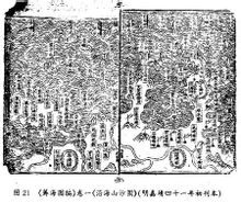
In many coastal map, ought to "chip chart compiled" the most authoritative because it is led by Zhejiang Governor Zongxian completed Poet data comes government action. The map also reflects the seas, large and small islands are named in Chinese naming manner, highlighting China named form, sound, meaning three-pronged important feature. Meanwhile, the names of all of the islands have been repeatedly approved by the Ming government formally established the most commonly used name of the island. The diagram is operating under the jurisdiction of the coastal islands Ming government's most original map records which clearly credited to the Jilongshan, vases mountain, Peng hiking, fishing, island, Mount of Olives, Rattus Hill, Red Island and other islands, but China seamount an island of natural stone chain. They are the Ming government anti-Japanese Imperial Army Kou water will come to the waters, but also in Zhejiang, Fujian and Taiwan's coastal fishing waters of the Diaoyu Islands fishing grounds. Name of the Diaoyu Islands and other islands explicitly into China Fujian community, operating under the jurisdiction of the Chinese Ming government vast waters of the East China Sea coast of the important achievements of the Qing government-run sovereign territorial waters and sovereignty lay the waters literature base map. Volume book "Coastal Sand Hill map" "Fu seven", "blessing eight" two chart (see Figure), the top row to the left fifth own island "Jilongshan" onwards, followed by a Peng hiking, fishing, island , vases Hill, Rattus mountain, Mount of Olives, red island and other islands. Clear: as the Ming Dynasty Poet's Zongxian highest military officer, the Diaoyu Islands and other islands have been included in China's coastal areas. "Coastal Sand Hill map" "Fu seven", "blessing eight
》
In the 72 "coastal mountain sand map" marked on the island, there is an island in other countries, are all Chinese island. In fact, by land and sea, land and under the sea, from south to north, endless, maps sketched out from the mouth of the Yalu River along the coast of Guangdong to the screen, if you do not follow through coherent representation of the page, then it is difficult to enlarge the drawing, and more impossible to draw the details. Of particular note is that the upper-right corner of each graph are marked with the serial number, especially at the beginning of each province's first piece depicting upper right corner of the map explicitly written, "a province bounded one," for example, the first piece of Fujian map the upper right corner that says "Fujian circles a", then followed by the "Fujian two", "Fujian three" until "Fujian nine", the other provinces also do so。According to this logic and Chinese language style omit habits (Japanese kanji used in a similar omitted), it is very clear to the reader, the provinces contiguous pages is the province's overall scope of provincial boundaries. Another example, in Liaodong example, its upper right corner of the first picture is "Liaodong circles a" supposedly Liaodong adjacent North Korea, but the last one Liaodong map "Liaodong five" and did not depict the adjacent North Korea map out , but with characters that "since then into North Korea border." Therefore, "chip chart compiled" and "coastal mountain sand drawing" a collection of pirates suffered harassment throughout China coastal map, southwest to the northeast for the order, but in areas outside China's territory are not incorporated, so the Japanese O'Yuan Toshio the so-called "not only Chinese territory Diaoyu Islands" remarks are unfounded.
To challenge world record please E-mail : s@carryingtheflag.com or s@kangqi.org
Previous :Currently the world's earliest known r…
Next:Using the world's largest number of lo…
E-mail:s@carryingtheflag.com
URL:www.carryingtheflag.com


- · The world's youngest boy fla…
- · Fujian Chen Po reporting suc…
- · Luoyang, Henan Province Mr. …
- · Guangxi Mr. Li Shoulong repo…
- · Jilin Wang Qian one thousand…
- · Guangxi Mr. Zeng Demin repor…
- · Sichuan Zhouguang Hong repor…
- · Mianyang Mr. Zeng Tianshi re…
- · Mr. Daye Ke Youcai reporting…
- · Beijing Mr. Cui Changxi repo…
- · Shanghai Wang Fei, Mr. Wang …
- · Zhejiang Mr. Zheng Xuesong r…
- · Chengdu Fu Suqing reporting …
- · Chongqing Jiang Ruishen news…
- · Chongqing Zhao Hangshen news…
- · Chengdu, Sichuan, Mr. Lan Ji…
- · 2012 over 1000 declaration b…
- · Chongqing Wei Hongyu reporti…
- · Sichuan Guangyuan He Kangshe…
- · Sichuan Guangyuan He Kangshe…